Category Archives: en

The Relocation of Indonesia’s Capital: From Jakarta to Nusantara

Smog in Jakarta

Indonesia is in the process of relocating its capital from Jakarta to a newly planned city called Nusantara. This decision was made due to Jakarta’s overpopulation, environmental challenges, and economic considerations. The relocation marks one of the most ambitious infrastructure projects in Indonesia’s history.

Nusantara presidental palace

Reasons for Moving the Capital

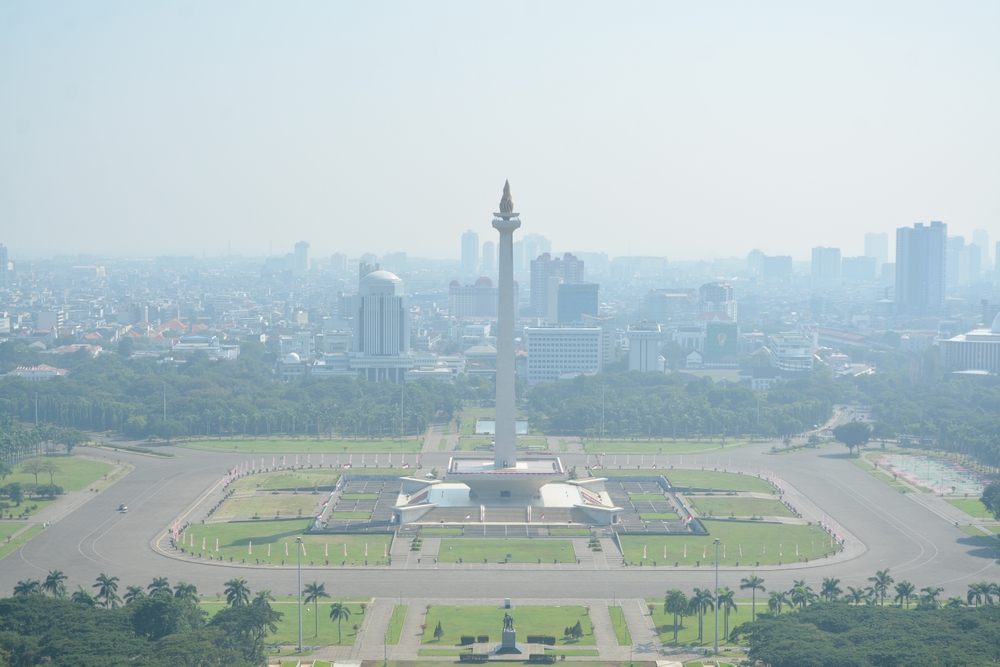
Jakarta, located on the island of Java, has long served as Indonesia’s capital. However, the city faces multiple challenges that prompted the government to consider a relocation:

  • Severe Overpopulation: Jakarta is home to over 10 million people, with the greater metropolitan area exceeding 30 million. This has led to chronic traffic congestion and urban crowding.
  • Environmental Concerns: Jakarta is sinking due to excessive groundwater extraction. Parts of the city are subsiding by as much as 25 cm per year, increasing the risk of severe flooding.
  • Economic Imbalance: Java dominates Indonesia’s economy, while other islands remain underdeveloped. Moving the capital is intended to promote economic growth in other regions.

Choosing Nusantara

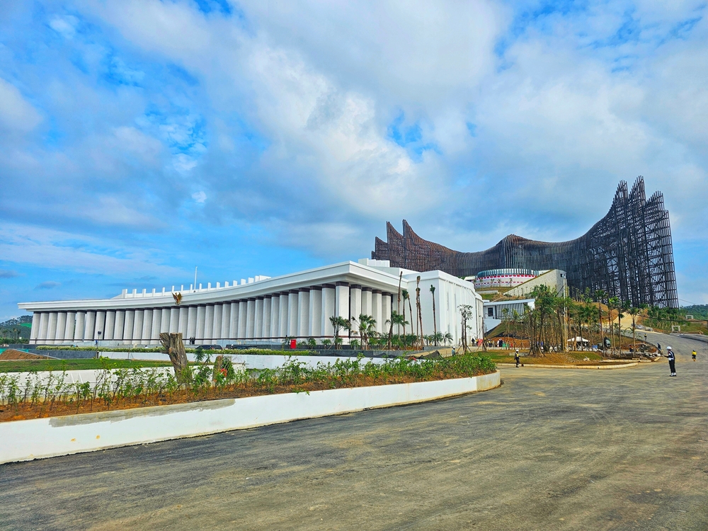
In 2019, President Joko Widodo announced plans to relocate the capital to East Kalimantan, on the island of Borneo. The new city, named Nusantara, was chosen for its central location, lower population density, and reduced environmental risks.

Construction and Development

The construction of Nusantara officially began in 2022, with plans to complete the first phase by 2024. The key aspects of the development include:

  • Green and Smart City: Nusantara is designed to be environmentally sustainable, using renewable energy and smart infrastructure.
  • Decentralization: The move is expected to distribute economic opportunities beyond Java.
  • Government Relocation: Key government institutions, including the presidential office, are set to move to Nusantara.

Challenges and Criticism

Despite the ambitious plans, the relocation faces several challenges:

  • High Costs: The estimated cost of building Nusantara is around $32 billion, requiring significant investment.
  • Environmental Concerns: Although intended as a sustainable city, some fear that development in Borneo could lead to deforestation and harm biodiversity.
  • Logistical Issues: Moving government offices and infrastructure from Jakarta to Nusantara is a complex and time-consuming process.

Conclusion

Indonesia’s decision to relocate its capital from Jakarta to Nusantara is a historic move aimed at addressing overpopulation, environmental risks, and economic imbalance. While the project presents significant opportunities, it also comes with financial and environmental challenges. The success of Nusantara will depend on careful planning and execution in the coming years.

The Name Changes of Astana: A Capital in Flux

Astana, the capital of Kazakhstan, has undergone multiple name changes throughout its history. These changes reflect political transitions, national identity shifts, and the influence of Kazakhstan’s leadership. Below is an overview of the city’s historical names and the reasons behind each change.

Akmolinsk (1830–1961)

The settlement was founded in 1830 as a Russian military outpost and was named Akmolinsk. The name derives from “Ak-Mola,” meaning “White Shrine” or “Holy Place” in Kazakh, possibly referring to a local burial site or geographical feature.

Tselinograd (1961–1992)

During the Soviet Union’s Virgin Lands Campaign, aimed at increasing agricultural production in northern Kazakhstan, the city was renamed Tselinograd (from the Russian “Tselina,” meaning “virgin lands”). This renaming emphasized the city’s role in the large-scale Soviet agricultural project.

Akmola (1992–1998)

After Kazakhstan gained independence in 1991, the government sought to restore Kazakh identity to place names. In 1992, the city reverted to a variation of its original name, Akmola, aligning with the country’s move away from Soviet-era names.

Astana (1998–2019)

In 1997, Kazakhstan’s capital was moved from Almaty to Akmola, primarily due to Almaty’s geographic limitations and earthquake risk. In 1998, the city was renamed Astana, which simply means “capital” in Kazakh. The name was chosen to avoid favoring any particular historical figure or political ideology.

Nur-Sultan (2019–2022)

In 2019, after the resignation of Kazakhstan’s long-time president Nursultan Nazarbayev, his successor, Kassym-Jomart Tokayev, proposed renaming Astana to Nur-Sultan in his honor. This change was quickly approved, marking the city’s most politically motivated renaming. However, it faced public opposition, as many residents preferred the neutral name “Astana.”

Return to Astana (2022–Present)

In September 2022, following public dissatisfaction and political shifts, President Tokayev signed a decree restoring the city’s name to Astana. This decision was part of a broader effort to distance the country from excessive political leader worship and to reflect the population’s preference.

Conclusion

Astana’s name changes mirror Kazakhstan’s historical and political transformations. From its early days as Akmolinsk to the present, each renaming reflects a shift in national priorities, governance, and public sentiment. Whether the name remains “Astana” or changes again in the future remains an open question, but the city’s evolving identity will continue to be closely tied to the nation’s political landscape.

What Is An Exonym?

An exonym is a name used in one language or culture to refer to a geographic location (a city, country, region, or natural feature) situated within a different language area or cultural context. In other words, it is how people outside a place name it, rather than the name used locally by the inhabitants themselves.

For example, in English we say “Germany” for what Germans call “Deutschland,” and “Florence” for the Italian city known locally as “Firenze.” Those English names are exonyms. Meanwhile, the endonym (or autonym) is the name in the region’s own language—like “Deutschland” or “Firenze” in those two examples.

Exonyms arise for several reasons. Sometimes they reflect older historical names carried through centuries of trade and travel. In other cases, they are the result of different sounds and spelling conventions in the adopting language. While exonyms can provide familiarity and ease of pronunciation for speakers of a particular language, modern usage trends may lean more toward using local (endonymic) spellings or pronunciations, especially when respect for cultural or linguistic identity is a priority.

Game Modes

Our geography games on the Ekvis website offer a variety of game modes. Use the dropdown below the map to select a different mode and explore new challenges!

Show All: A learning mode where all locations are displayed on the map, allowing you to study and familiarize yourself with them.

Pin: Click on the exact location you’re prompted to find.

Pin (easy): Similar to ‘Pin,’ but three possible areas are highlighted, making it easier to choose the correct one.

Pin (very easy): Similar to ‘Pin,’ but as you hover over locations, their names are displayed to assist you.

Pin (no borders): Similar to ‘pin’, but the borders between countries are not visible, making the game a lot more challenging! (This is not available in city quizzes).

Muitiple Choice: Choose between four alternative names.

Type random: Type the names in any order, and they will be highlighted on the map as you go.

Type: Type the name of the highlighted country.

Fly: Use the arrow keys or WASD to steer, and press the spacebar for a speed boost.

Why Did Canada Not Become Part of the United States?

Despite their shared geography, language, and historical connections, Canada and the United States developed as separate nations. Several key factors explain why Canada did not join the U.S.:

1. Loyalist Influence After the American Revolution

During the American Revolution (1775–1783), many colonists remained loyal to Britain. These Loyalists (including soldiers, officials, and civilians) fled to British-controlled territories in the north, strengthening their British identity. This deepened the divide between the new United States and what would become Canada.

2. The War of 1812

The U.S. attempted to invade British North America (now Canada) during the War of 1812, hoping to expand its territory. However, British troops, Canadian militias, and Indigenous allies successfully resisted American forces. This conflict reinforced a Canadian identity separate from the U.S. and increased loyalty to Britain.

3. Cultural and Political Differences

Canada remained under British rule longer and developed a government based on British parliamentary traditions. The U.S., in contrast, embraced a republican system with elected leaders and no ties to the monarchy. These differences created a distinct political and cultural identity for Canada.

4. Economic and Military Ties to Britain

Throughout the 19th century, Canada benefited from economic and military support from Britain. The British government invested in Canadian infrastructure, such as railways, and provided military protection. This support made merging with the U.S. less attractive.

5. Fear of American Expansionism

During the 19th century, the U.S. followed a policy of Manifest Destiny, seeking to expand westward. Many Canadians feared that joining the U.S. would mean being absorbed into an expansionist country that might not respect their existing rights and institutions.

6. The Formation of Canada (1867)

Instead of joining the U.S., the colonies of British North America united to form the Dominion of Canada in 1867 under the British North America Act. This move was partly to strengthen the region against potential U.S. expansion and to establish a self-governing nation under British influence.

Conclusion

Canada remained separate from the U.S. due to a combination of historical loyalty to Britain, military conflicts, cultural differences, economic ties, and concerns over American expansion. Instead of joining the U.S., Canada developed its own path, eventually becoming a fully independent country while maintaining ties to Britain.

Which Country Does Crimea Belong To?

Crimea map Russia Ukraine

Crimea is a region that has been at the center of international disputes in recent years. Officially, according to international law and the majority of the global community, Crimea is part of Ukraine. However, since 2014, it has been under Russian control following a disputed referendum and subsequent annexation by Russia.

Ukraine’s Claim

Crimea was an autonomous republic within Ukraine before 2014. The United Nations and most countries continue to recognize it as Ukrainian territory, citing Ukraine’s internationally recognized borders. Ukraine considers Russia’s presence in Crimea an illegal occupation.

Russia’s Claim

Russia, on the other hand, argues that the 2014 referendum—where a reported majority of Crimeans voted to join Russia—justifies its control. However, this referendum is widely regarded as illegitimate due to the presence of Russian military forces and the lack of international oversight.

International Response

Most countries, including the United States and the European Union, do not recognize Crimea as part of Russia and have imposed sanctions on Russia for the annexation. A few countries, such as Belarus and North Korea, acknowledge Russian sovereignty over the region.

Conclusion

While Crimea is de facto controlled by Russia, it remains de jure part of Ukraine under international law. The issue continues to be a major point of tension in global politics.

Ekvis Speedrun Contest (March 2025)🏆

🎉 The Third Ekvis Contest is Here! 🎉

Following the success of our previous competitions, we’re thrilled to introduce the next geography speedrunning contest!

📅 Contest Dates: March 1st – March 8th, 2025

🗺️ Map: 193 UN Member States (any language)

🎮 Game Mode: Any mode you like!

⚠️ Important: If you play in Type Random or Multiple Choice using the keyboard, you must have a webcam on your keyboard.

👉 Play here

🏆 Prizes

Fastest Time – $20
A $20 prize will be awarded to the contestant with the fastest completion time.

Fastest Time in a Different Game Mode – $20
A $20 prize will be awarded to the contestant with the fastest time in a different game mode than the first-prize winner.

📜 Additional Rules and Info

  • To participate, you must be a member of the Ekvis Discord server.
  • Entries should be posted in the #🏆│contest-entries channel on Discord and must include a YouTube link to your video along with the in-game time shown in the video.
  • The use of macros, autoclickers, or any other external tools is strictly prohibited.
  • Prize money will be paid via PayPal or Swish (for participants in Sweden).
  • Winners will also receive a special role in the Ekvis Discord server as recognition for their achievement.

How Many Continents Are There?


The number of continents isn’t as straightforward as it seems—it depends on how a continent is defined. Different cultures and perspectives have led to various models of continental division.

The Most Common Model: Seven Continents

Continents
The seven continent model

 The most widely accepted system, particularly in English-speaking countries, recognizes seven continents:

  • Asia – The largest continent by both area and population.
  • Africa – Known for its vast deserts, rainforests, and diverse wildlife.
  • North America – Home to the United States, Canada, and Mexico, among others.
  • South America – Rich in natural resources and biodiversity.
  • Antarctica – A frozen continent with no permanent human population.
  • Europe – A continent with a rich history of civilization and culture.
  • Australia – Often referred to as both a continent and a country.

This seven-continent model is taught in many parts of the world, including the United States, Canada, the United Kingdom, and Australia.

The Six-Continent Model

Some regions, particularly in Europe and Latin America, follow a six-continent model, which combines certain landmasses differently:

  • Eurasia Model: Europe and Asia are considered one single continent, as they form a continuous landmass without a clear geological separation. This results in the following six continents: Africa, North America, South America, Antarctica, Eurasia, and Australia.
  • America Model: North and South America are treated as a single continent, simply called America, leading to another six-continent model: Africa, America, Antarctica, Asia, Europe, and Australia.

The Five-Continent Model

The Olympic Rings represent five continents: Africa, the Americas, Asia, Europe, and Oceania. This model is mainly symbolic, used in the context of the Olympic Games rather than in geography education.

Other Perspectives

The Four-Continent Model

A minority view groups continents by geological or historical connections, leading to a four-continent system: Afro-Eurasia, America, Antarctica, and Australia.

Tectonic Plate Perspective

Geologists sometimes view continents differently based on tectonic plates rather than traditional landmasses. This perspective leads to various interpretations, such as Zealandia, a mostly submerged continent in the Pacific, which includes New Zealand.

Conclusion

The number of continents varies depending on cultural, geographical, and scientific perspectives. The seven-continent model is the most commonly used, but six-, five-, and even four-continent models also exist. 

Ekvis Map Quizzes Tips & Tricks

Discover a collection of useful tips and tricks to help you get the most out of the Ekvis map quizzes! Whether you’re aiming to improve your geography knowledge, challenge yourself with harder modes, or simply enjoy the experience, these suggestions will guide you in making the most of every quiz. From mastering game mechanics to exploring different modes, there’s something here for everyone looking to level up their skills.

Full Screen Mode

Click the rectangle in the lower right corner of the map to enter or exit full screen mode. You can also press alt+F.

Toggle Labels

Visible labels can be helpful for learning but can also make the screen feel cluttered or make it hard to click objects below them. With Ekvis, you have the option to show or hide labels anytime during gameplay. Simply click the button next to the full-screen icon to toggle them.

Customizing The Interface

You can move the statistics bar and the flag at the top of the map around by dragging the dotted handles. Hide or show the flag by clicking the arrow next to the dotted handle.

Search Function

Don’t forget to take advantage of the search function! It’s a quick and efficient way to locate the quiz you’re looking for. Simply use the search bar located in the header to find your desired quiz in no time.

Switching Language

The map quizzes are available in many different languages. Use the language drop down to switch language.

This quiz is available in both English and Spanish, which you can identify by the bolded language names. Selecting Spanish will take you to the same quiz in Spanish, while choosing any other language will redirect you to a list of map quizzes available in that language.

Keyboard Shortcuts

Alt+R: Restart the game
Alt+F: Full screen mode

Dark Mode

Turn on Dark mode by checking the checkbox in the site footer.

Steering in Fly mode

In fly mode, use either the arrow keys for steering, or the WASD keys. The space key gives the plane an extra speed boost.

Linking Directly to Game Modes

You can link directly to game mode by adding a querystring parameter after the link.

Show All: https://ekvis.com/en/g-eur01?gamemode=showall
Pin (very easy): https://ekvis.com/en/g-eur01?gamemode=pinveryeasy
Pin (easy): https://ekvis.com/en/g-eur01?gamemode=pineasy
Pin: https://ekvis.com/en/g-eur01?gamemode=pin
Pin (hard): https://ekvis.com/en/g-eur01?gamemode=pinhard
Pin (no borders): https://ekvis.com/en/g-eur01?gamemode=pinnoborders
Type random: https://ekvis.com/en/g-eur01?gamemode=typerandom
Fly: https://ekvis.com/en/g-eur01?gamemode=fly
Fly (hard): https://ekvis.com/en/g-eur01?gamemode=flyhard

Fastclick

If you are a speedrunner and want to get the fastest time possible, add ?fastclick=1 after the link. Example: https://ekvis.com/en/g-eur01?fastclick=1 . This causes the clicks to register on mouse down instead of mouse up.

Hoverclick

Hoverclick is a challenging and unconventional game mode where your mouse automatically clicks as you move it. You can enable this mode by adding a parameter: https://ekvis.com/en/g-eur01?hoverclick=1

Memorizing The US States Fast

Easily Memorize The 50 States Video

The video titled Easily Memorize the 50 States provides a creative and visual method to help memorize the U.S. states. The presenter, Eric from the Eric the Elephant YouTube channel, adapts and expands on a method he learned, using mnemonic devices and visual cues based on the shapes and positions of the states on a map, similar to Nelson’s video. Here’s a summary of his approach:

  1. Regional Mnemonics:
    • Starts with the southern border states using “can’t” for California, Arizona, New Mexico, and Texas.
    • Uses “nuck” (Nevada, Utah, Colorado, Kansas) and a “K column” for North DaKota, South DaKota, NebrasKa, Kansas, and OKlahoma.
  2. Shapes and Imagery:
    • Washington and Oregon are remembered as “wo” (afraid to walk off the map into the ocean).
    • Idaho as a lowercase “i”; Montana as an upside-down “M” resembling mountain ranges.
    • Wyoming is personified as “why would you forget about me” (a forgotten state).
    • Minnesota becomes “Minnie Mouse,” and neighboring states are linked as “MIMAL” (Minnesota , Iowa, Missouri, Arkansas, Louisiana).
  3. Great Lakes Region:
    • States around the Great Lakes (Wisconsin, Illinois, Indiana, Michigan, Ohio, Pennsylvania) are linked to water and the concept of “mopping”. WII MOP? Because there is a lot of water in the lakes!
  4. East Coast:
    • Uses shapes and features to remember New England states, like a massive hook for Massachusetts and a “y” for New York, h for New Hampshire and V for Vermont.
    • Rhode Island is small because islands are generally small.
    • Connecticut connects Rhose Island and New York.
    • New Jersey looks like a capital J
    • Maryland is associated with water and happiness. They are “merry” because they have so much water.
    • Virginia is an upside-down “V,” and West Virginia is west of it.
  5. Southern States:
    • Kentucky is imagined as a drumstick (Kentucky Fried Chicken).
    • Tennessee is a “long gun barrel”, and more than ten people have guns there, with Mississippi, Alabama, and Georgia as the MAGazine below for loading it.
  6. Final States:
    • North Carolina and South Carolina resemble a “C.”
    • Florida is a backward “F.”
    • Alaska is a lowercase “a.”
    • Hawaii is remembered as “Hi Hawaii” because it’s far off the map.

The video uses humor, imagination, and repetition to create memorable associations for each state, making it easier to learn and recall them.

Do you have a map test coming up and need to learn the 50 states quickly? Don’t worry—there are plenty of tips and tricks to make it easier!

The best tip in this Youtube video by Nelson Dellis is the use of mnemonics and visual associations to memorize all 50 U.S. states. Nelson breaks the map into regions and uses memorable stories and patterns to link state names to their locations. For example:

  1. “Can’t” mnemonic: For southern border states – California, Arizona, New Mexico, and Texas.
  2. “Knuck” mnemonic: For states like Nevada, Utah, Colorado, and Kansas, imagining a duck knocking to get past the border.
  3. Visual shapes: Associating state shapes with objects or letters, such as Oklahoma as a meat cleaver, Idaho as a lowercase “i,” and Montana as mountains.
  4. Storytelling: Grouping states into humorous or imaginative scenarios, such as a chef (Mr. MIMAL) to represent Minnesota, Iowa, Missouri, Arkansas, and Louisiana.

These creative connections make the state names and locations easier to recall by turning abstract geography into fun and vivid mental images.


Tour The States Video

If you need to learn both the states and their capitals, the engaging video Tour the States could be a great resource. In the video, the presenter draws a map and adds symbols for each state along with its capital. Once you’ve memorized the catchy lyrics, you’ll know all 50 state capitals by heart!

Testing Your Knowledge

Test your knowledge of all the states with our US Map Quiz. If you’d like, you can focus on the states east of the Mississippi or the states west of the Mississippi, or the state capitals.