How Many Continents Are There?


The number of continents isn’t as straightforward as it seems—it depends on how a continent is defined. Different cultures and perspectives have led to various models of continental division.

The Most Common Model: Seven Continents
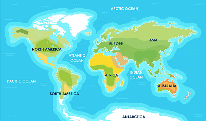
Continents
The seven continent model

 The most widely accepted system, particularly in English-speaking countries, recognizes seven continents:

  • Asia – The largest continent by both area and population.
  • Africa – Known for its vast deserts, rainforests, and diverse wildlife.
  • North America – Home to the United States, Canada, and Mexico, among others.
  • South America – Rich in natural resources and biodiversity.
  • Antarctica – A frozen continent with no permanent human population.
  • Europe – A continent with a rich history of civilization and culture.
  • Australia – Often referred to as both a continent and a country.

This seven-continent model is taught in many parts of the world, including the United States, Canada, the United Kingdom, and Australia.

The Six-Continent Model

Some regions, particularly in Europe and Latin America, follow a six-continent model, which combines certain landmasses differently:

  • Eurasia Model: Europe and Asia are considered one single continent, as they form a continuous landmass without a clear geological separation. This results in the following six continents: Africa, North America, South America, Antarctica, Eurasia, and Australia.
  • America Model: North and South America are treated as a single continent, simply called America, leading to another six-continent model: Africa, America, Antarctica, Asia, Europe, and Australia.

The Five-Continent Model

The Olympic Rings represent five continents: Africa, the Americas, Asia, Europe, and Oceania. This model is mainly symbolic, used in the context of the Olympic Games rather than in geography education.

Other Perspectives

The Four-Continent Model

A minority view groups continents by geological or historical connections, leading to a four-continent system: Afro-Eurasia, America, Antarctica, and Australia.

Tectonic Plate Perspective

Geologists sometimes view continents differently based on tectonic plates rather than traditional landmasses. This perspective leads to various interpretations, such as Zealandia, a mostly submerged continent in the Pacific, which includes New Zealand.

Conclusion

The number of continents varies depending on cultural, geographical, and scientific perspectives. The seven-continent model is the most commonly used, but six-, five-, and even four-continent models also exist. 

Ekvis Map Quizzes Tips & Tricks

Discover a collection of useful tips and tricks to help you get the most out of the Ekvis map quizzes! Whether you’re aiming to improve your geography knowledge, challenge yourself with harder modes, or simply enjoy the experience, these suggestions will guide you in making the most of every quiz. From mastering game mechanics to exploring different modes, there’s something here for everyone looking to level up their skills.

Full Screen Mode

Click the rectangle in the lower right corner of the map to enter or exit full screen mode. You can also press alt+F.

Toggle Labels

Visible labels can be helpful for learning but can also make the screen feel cluttered or make it hard to click objects below them. With Ekvis, you have the option to show or hide labels anytime during gameplay. Simply click the button next to the full-screen icon to toggle them.

Customizing The Interface

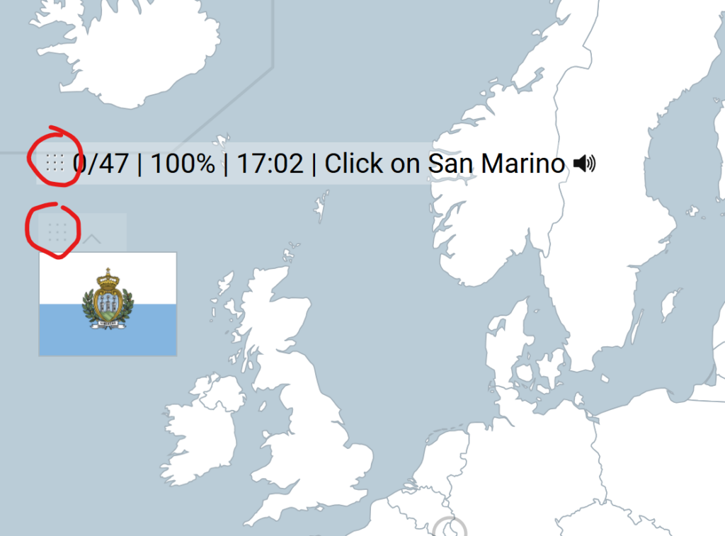
You can move the statistics bar and the flag at the top of the map around by dragging the dotted handles. Hide or show the flag by clicking the arrow next to the dotted handle.

Search Function

Don’t forget to take advantage of the search function! It’s a quick and efficient way to locate the quiz you’re looking for. Simply use the search bar located in the header to find your desired quiz in no time.

Switching Language

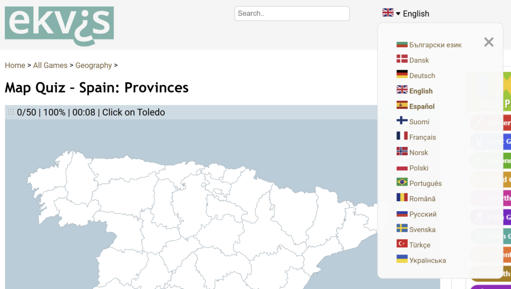
The map quizzes are available in many different languages. Use the language drop down to switch language.

This quiz is available in both English and Spanish, which you can identify by the bolded language names. Selecting Spanish will take you to the same quiz in Spanish, while choosing any other language will redirect you to a list of map quizzes available in that language.

Keyboard Shortcuts

Alt+R: Restart the game
Alt+F: Full screen mode

Dark Mode

Turn on Dark mode by checking the checkbox in the site footer.

Steering in Fly mode

In fly mode, use either the arrow keys for steering, or the WASD keys. The space key gives the plane an extra speed boost.

Linking Directly to Game Modes

You can link directly to game mode by adding a querystring parameter after the link.

Show All: https://ekvis.com/en/g-eur01?gamemode=showall
Pin (very easy): https://ekvis.com/en/g-eur01?gamemode=pinveryeasy
Pin (easy): https://ekvis.com/en/g-eur01?gamemode=pineasy
Pin: https://ekvis.com/en/g-eur01?gamemode=pin
Pin (hard): https://ekvis.com/en/g-eur01?gamemode=pinhard
Pin (no borders): https://ekvis.com/en/g-eur01?gamemode=pinnoborders
Type random: https://ekvis.com/en/g-eur01?gamemode=typerandom
Fly: https://ekvis.com/en/g-eur01?gamemode=fly
Fly (hard): https://ekvis.com/en/g-eur01?gamemode=flyhard

Fastclick

If you are a speedrunner and want to get the fastest time possible, add ?fastclick=1 after the link. Example: https://ekvis.com/en/g-eur01?fastclick=1 . This causes the clicks to register on mouse down instead of mouse up.

Hoverclick

Hoverclick is a challenging and unconventional game mode where your mouse automatically clicks as you move it. You can enable this mode by adding a parameter: https://ekvis.com/en/g-eur01?hoverclick=1

Memorizing The US States Fast

Easily Memorize The 50 States Video

The video titled Easily Memorize the 50 States provides a creative and visual method to help memorize the U.S. states. The presenter, Eric from the Eric the Elephant YouTube channel, adapts and expands on a method he learned, using mnemonic devices and visual cues based on the shapes and positions of the states on a map, similar to Nelson’s video. Here’s a summary of his approach:

  1. Regional Mnemonics:
    • Starts with the southern border states using “can’t” for California, Arizona, New Mexico, and Texas.
    • Uses “nuck” (Nevada, Utah, Colorado, Kansas) and a “K column” for North DaKota, South DaKota, NebrasKa, Kansas, and OKlahoma.
  2. Shapes and Imagery:
    • Washington and Oregon are remembered as “wo” (afraid to walk off the map into the ocean).
    • Idaho as a lowercase “i”; Montana as an upside-down “M” resembling mountain ranges.
    • Wyoming is personified as “why would you forget about me” (a forgotten state).
    • Minnesota becomes “Minnie Mouse,” and neighboring states are linked as “MIMAL” (Minnesota , Iowa, Missouri, Arkansas, Louisiana).
  3. Great Lakes Region:
    • States around the Great Lakes (Wisconsin, Illinois, Indiana, Michigan, Ohio, Pennsylvania) are linked to water and the concept of “mopping”. WII MOP? Because there is a lot of water in the lakes!
  4. East Coast:
    • Uses shapes and features to remember New England states, like a massive hook for Massachusetts and a “y” for New York, h for New Hampshire and V for Vermont.
    • Rhode Island is small because islands are generally small.
    • Connecticut connects Rhose Island and New York.
    • New Jersey looks like a capital J
    • Maryland is associated with water and happiness. They are “merry” because they have so much water.
    • Virginia is an upside-down “V,” and West Virginia is west of it.
  5. Southern States:
    • Kentucky is imagined as a drumstick (Kentucky Fried Chicken).
    • Tennessee is a “long gun barrel”, and more than ten people have guns there, with Mississippi, Alabama, and Georgia as the MAGazine below for loading it.
  6. Final States:
    • North Carolina and South Carolina resemble a “C.”
    • Florida is a backward “F.”
    • Alaska is a lowercase “a.”
    • Hawaii is remembered as “Hi Hawaii” because it’s far off the map.

The video uses humor, imagination, and repetition to create memorable associations for each state, making it easier to learn and recall them.

Do you have a map test coming up and need to learn the 50 states quickly? Don’t worry—there are plenty of tips and tricks to make it easier!

The best tip in this Youtube video by Nelson Dellis is the use of mnemonics and visual associations to memorize all 50 U.S. states. Nelson breaks the map into regions and uses memorable stories and patterns to link state names to their locations. For example:

  1. “Can’t” mnemonic: For southern border states – California, Arizona, New Mexico, and Texas.
  2. “Knuck” mnemonic: For states like Nevada, Utah, Colorado, and Kansas, imagining a duck knocking to get past the border.
  3. Visual shapes: Associating state shapes with objects or letters, such as Oklahoma as a meat cleaver, Idaho as a lowercase “i,” and Montana as mountains.
  4. Storytelling: Grouping states into humorous or imaginative scenarios, such as a chef (Mr. MIMAL) to represent Minnesota, Iowa, Missouri, Arkansas, and Louisiana.

These creative connections make the state names and locations easier to recall by turning abstract geography into fun and vivid mental images.


Tour The States Video

If you need to learn both the states and their capitals, the engaging video Tour the States could be a great resource. In the video, the presenter draws a map and adds symbols for each state along with its capital. Once you’ve memorized the catchy lyrics, you’ll know all 50 state capitals by heart!

Testing Your Knowledge

Test your knowledge of all the states with our US Map Quiz. If you’d like, you can focus on the states east of the Mississippi or the states west of the Mississippi, or the state capitals.

India’s Border Conflicts: A Complex History

India, with its extensive and diverse borders, has faced several long-standing border conflicts with its neighbors, primarily China and Pakistan. These disputes stem from historical territorial claims, political tensions, and strategic interests.

One of the most prominent conflicts is the Kashmir dispute with Pakistan, which began after the partition of British India in 1947. Both countries claim the region in its entirety, leading to multiple wars and ongoing skirmishes along the Line of Control (LoC). The region remains highly militarized and volatile, with frequent ceasefire violations.

India also has border disputes with China, particularly in the areas of Aksai Chin and Arunachal Pradesh. The 1962 Sino-Indian War was fought over these territories, and tensions have persisted ever since. In recent years, clashes along the Line of Actual Control (LAC), such as the 2020 Galwan Valley skirmish, have reignited concerns about stability in the region.

Despite attempts at diplomacy, including talks and agreements, these border conflicts remain unresolved.

Read more on Wikipedia: https://en.wikipedia.org/wiki/Disputed_territories_of_India

> Play our Asia map quiz game to learn all the countries in Asia
> Play our map game on the states of India

Illinois Residents to Vote on New State Flag Design

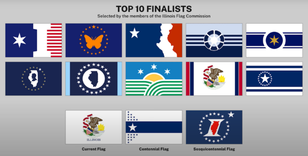
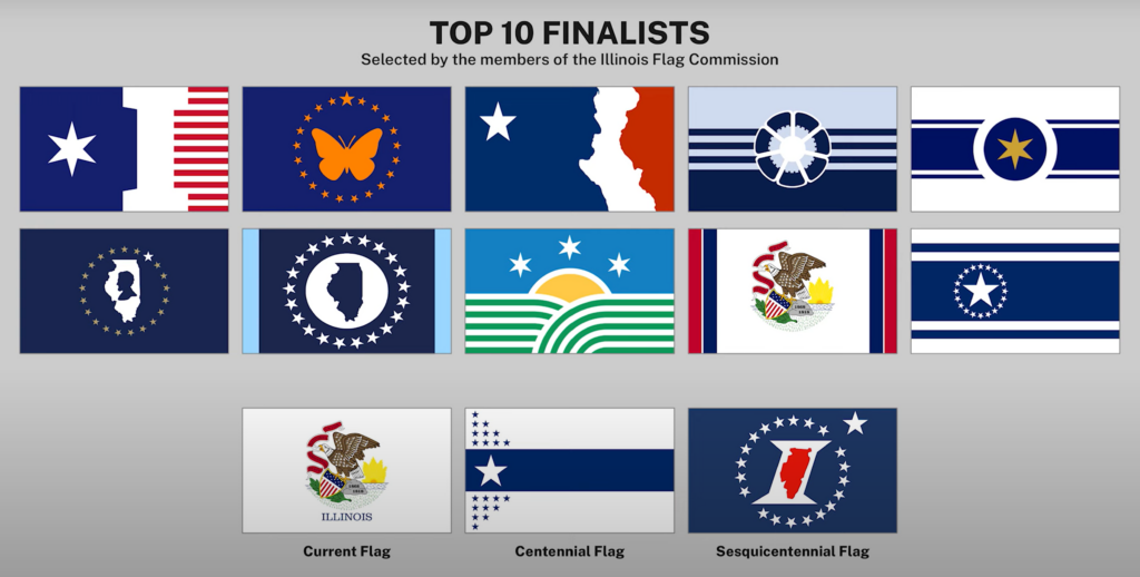
The state of Illinois is holding a public vote to decide the future of its state flag. After nearly 5,000 designs were submitted in a statewide competition, the Illinois Flag Commission selected ten finalists to represent the state’s identity.

From January 1 to March 15, 2025, residents can cast their votes online. The results will guide the Illinois General Assembly in determining whether to adopt a new flag or retain the existing one, marking a significant moment in the state’s history.


The Illinois flag redesign vote not only includes the top ten finalist designs selected by the Illinois Flag Commission but also offers three additional options: the current Illinois state flag, the Centennial flag, and the Sesquicentennial flag. These options provide voters with the chance to either embrace a historic design or choose one of the proposed new symbols for the state.

> Read about other US states that have recently changed their flags
> Try our US map quiz game with updated flags

Is Taiwan a Country?

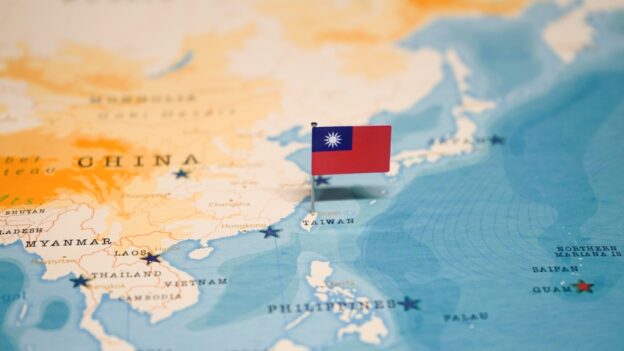
The question of whether Taiwan is a country is highly debated and complex. Officially known as the Republic of China (ROC), Taiwan has its own government, a democratic political system, and operates as a de facto independent state. However, the People’s Republic of China (PRC) considers Taiwan a part of its territory and strongly opposes any move toward formal independence.

Historical Background

The issue dates back to 1949, when the Chinese Civil War ended with the Communist Party establishing the PRC on the mainland, while the nationalist government fled to Taiwan. Since then, Taiwan has maintained its own political system, distinct from the PRC. While it once claimed to represent all of China, Taiwan has since shifted its focus to its own governance.

International Recognition

Taiwan is not universally recognized as a sovereign state. Only a small number of countries maintain official diplomatic relations with Taiwan, as most nations, including the United States and European Union members, adhere to the “One China” policy, recognizing the PRC as the sole representative of China. However, many countries engage with Taiwan informally, maintaining economic and cultural ties.

Taiwan’s Perspective

Taiwan’s government and many of its citizens view the island as a sovereign nation, distinct from China. It has its own constitution, military, and economy. Despite limited formal recognition, Taiwan is a thriving democracy and an important global player, particularly in technology and trade.

China’s Stance

The PRC insists that Taiwan is an inseparable part of China and has not ruled out the use of force to achieve unification. Beijing exerts significant pressure on other nations and international organizations to isolate Taiwan diplomatically.

Conclusion

Whether Taiwan is a country depends on the perspective taken. While it functions as an independent state in practice, its legal and political status remains contested on the international stage, with no resolution in sight. Taiwan’s future remains a sensitive and critical issue in global geopolitics.

Är Västsahara ett land?

Västsahara är en av världens mest omtvistade regioner när det gäller självständighet. Det ligger i nordvästra Afrika och gränsar till Marocko, Mauretanien och Atlanten. Trots att området är rikt på naturresurser som fosfat och fiskevatten är dess status som land mycket osäker.

Historisk bakgrund

Västsahara var en spansk koloni fram till 1975, då Spanien drog sig tillbaka. Efter detta gjorde både Marocko och Mauretanien anspråk på området. Mauretanien gav upp sina krav 1979, men Marocko har fortsatt att kontrollera större delen av regionen. Samtidigt kämpar den sahariska befrielserörelsen, Polisariofronten, för självständighet och har utropat den Sahariska arabiska demokratiska republiken (SADR), som erkänns av flera afrikanska länder och en del andra stater.

Internationell status

Västsahara är inte erkänt som ett självständigt land av FN, och Marocko betraktar det som en del av sitt territorium. FN har klassificerat Västsahara som ett “icke-självstyrande område” och försöker hitta en lösning genom förhandlingar. Planerna på en folkomröstning om självständighet, som skulle organiseras av FN, har fastnat på grund av oenighet om vem som får rösta.

Sveriges inställning

Sverige har ännu inte erkänt Västsahara som ett självständigt land men har uttryckt stöd för en fredlig lösning som respekterar folkrätten och Västsaharas rätt till självbestämmande.

Sammanfattning

Om Västsahara är ett land är en fråga som beror på vem man frågar. I praktiken kontrolleras större delen av området av Marocko, medan Polisariofronten kämpar för självständighet. Den osäkra statusen gör Västsahara till en av de mest långdragna territoriella konflikterna i världen.

Är Kosovo ett land?

Kosovos status som land är en fråga som skapar delade åsikter i världen. Regionen, som ligger på Balkan, förklarade sig självständigt från Serbien den 17 februari 2008. Idag erkänner över 100 länder Kosovo som ett självständigt land, men flera stora länder, inklusive Serbien, gör det inte.

Historisk bakgrund

Kosovo var tidigare en självstyrande provins inom Jugoslavien. Under 1990-talet uppstod stora spänningar mellan Kosovos albanska majoritet och den serbiska minoriteten. Detta ledde till Kosovokriget 1998–1999, som slutade när NATO ingrep och FN tog över administrationen av området.

År 2008 utropade Kosovo sin självständighet från Serbien. Serbien har dock aldrig erkänt detta och hävdar att Kosovo fortfarande är en del av dess territorium.

Erkännande i världen

Om Kosovo är ett land eller inte beror på vem man frågar. Över 100 länder, inklusive USA, Storbritannien och en majoritet av EU:s medlemsländer, erkänner Kosovo som självständigt. Men stora länder som Ryssland, Kina och Indien gör det inte. Även inom EU finns fem länder, som Spanien och Grekland, som inte erkänner Kosovo.

Eftersom Kosovo saknar universellt erkännande är det inte medlem i FN. Ryssland och Kina blockerar Kosovos ansökan genom sitt veto i FN:s säkerhetsråd.

Sveriges inställning

Sverige erkände Kosovos självständighet 2008 och har sedan dess haft goda relationer med landet. Sverige har också stöttat Kosovo i dess utveckling, bland annat genom bistånd och hjälp med att bygga upp demokratiska institutioner.

Utmaningar för Kosovo

Kosovo fungerar i praktiken som ett självständigt land med egen regering och lagar. Men bristen på internationellt erkännande skapar problem. Det blir svårt att delta i internationella organisationer, och relationerna med Serbien är fortfarande ansträngda. Dessutom finns det spänningar i norra Kosovo, där många serber bor och ofta motsätter sig Kosovos styre.

>> Fler blogginlägg…

Is Kosovo a Country?

Kosovo’s status as a country is a subject of international debate and political complexity. Located in the Balkans, Kosovo declared independence from Serbia on February 17, 2008. While over 100 United Nations member states recognize Kosovo as an independent state, others, including Serbia and several major powers, do not.

Kosovo on the map

Historical Context

Kosovo has a long and contested history. Once an autonomous province within Yugoslavia, it became a focal point of ethnic tensions between its Albanian majority and Serb minority. These tensions culminated in the Kosovo War (1998–1999), which ended after NATO intervened and established a United Nations administration in the region.

Kosovo’s 2008 declaration of independence was a direct result of these historical grievances and its desire for self-determination. However, Serbia has consistently opposed this move, claiming that Kosovo remains a part of its sovereign territory.

International Recognition

The question of whether Kosovo is a country depends largely on international recognition. As of 2025, over 100 countries, including the United States, the United Kingdom, and most European Union members, recognize Kosovo as independent. However, significant countries like Russia, China, and India, as well as five EU states (Spain, Slovakia, Romania, Greece, and Cyprus), do not recognize its sovereignty.

Kosovo is not a member of the United Nations due to Russia and China’s veto power on the Security Council, both of whom support Serbia’s position.

Political and Legal Perspectives

Kosovo operates as an independent state, with its own government, constitution, and institutions. The International Court of Justice (ICJ) ruled in 2010 that Kosovo’s declaration of independence did not violate international law. However, this ruling did not resolve the issue of recognition, leaving its statehood largely a matter of politics.

Challenges to Statehood

Kosovo faces several challenges typical of countries with contested sovereignty. Its lack of universal recognition complicates its participation in international organizations and treaties. It also affects foreign investment and diplomatic relations. Moreover, the Serbian minority in northern Kosovo often resists Pristina’s authority, creating ongoing tensions within its borders.

Conclusion

Whether Kosovo is a country depends on the perspective taken. Functionally, it operates as a sovereign state with all the institutions of governance. Legally and politically, its status is contested, hinging on the recognition of other nations and the resolution of its relationship with Serbia.

>> Learn to find Kosovo on a map in our Europe map quiz

Is Western Sahara A Country?

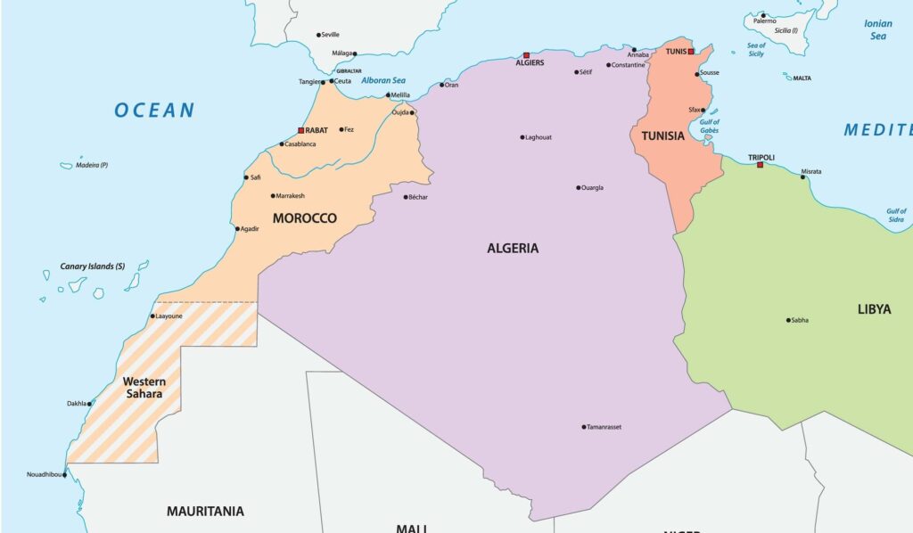
Map of Western Sahra in North Africa

Western Sahara, a sparsely populated region in North Africa, remains one of the world’s most protracted territorial disputes. Stretching along the Atlantic coast between Morocco and Mauritania, this region is rich in phosphate reserves and has significant fishing waters, making it strategically and economically important.

Historical Background

Formerly a Spanish colony, Western Sahara was claimed by both Morocco and Mauritania after Spain withdrew in 1975. Following a brief conflict, Mauritania relinquished its claim in 1979, leaving Morocco to assert control over most of the territory. However, the indigenous Sahrawi people, represented by the Polisario Front, demand independence and established the self-proclaimed Sahrawi Arab Democratic Republic (SADR), which is recognized by several nations and the African Union.

Current Governance and Conflict

Morocco administers about 80% of Western Sahara, including its major cities and natural resources, while the Polisario Front controls the remaining areas, primarily desert territories. A United Nations-brokered ceasefire in 1991 ended active hostilities, but plans for a referendum on the region’s future status have stalled due to disagreements over voter eligibility and terms.

International Perspectives

The international community remains divided on Western Sahara’s status. While Morocco has gained support for its proposal of autonomy under Moroccan sovereignty, the Polisario Front insists on a referendum that includes the option for independence. In recent years, the U.S. recognized Moroccan sovereignty over Western Sahara, further complicating the dispute. The United Nations continues to advocate for a negotiated solution but progress has been slow.

The unresolved conflict has left tens of thousands of Sahrawis living in refugee camps in Algeria, reliant on international aid. Allegations of human rights abuses, resource exploitation, and limitations on freedom of expression in the region contribute to ongoing tensions.