Author Archives: Marianne

Somaliland map

Israel Becomes the First Country to Recognize Somaliland

Somaliland map
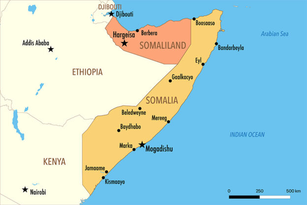
Map of Somaliland

In a historic decision on December 26, 2025, Israel became the first country in the world to officially recognize Somaliland as an independent country. This is a major moment because Somaliland had been trying to get global recognition for more than 30 years.

🗺️ What Is Somaliland?

Somaliland is a region in the Horn of Africa that used to be part of Somalia. It declared itself independent in 1991 after a long civil war in Somalia. Since then, it has run its own government, money, and security, but most countries in the world did not recognise it as a separate country — until now.

🤝 What Did Israel Do?

Israel and Somaliland signed an agreement that makes their relationship official. This means they will:

  • Exchange ambassadors
  • Open embassies
  • Work together on things like agriculture, technology, health, and the economy

The Israeli Prime Minister, Benjamin Netanyahu, called it a big step forward and said it fits with earlier peace deals known as the Abraham Accords — agreements that brought Israel closer to several countries in the Middle East.

🌍 Why Is This Important?

This matters for a few reasons:

  1. Strategic Location: Somaliland sits near important sea routes by the Red Sea and Gulf of Aden. These waters connect Europe, Africa, and Asia, so countries care a lot about security there.
  2. Regional Reactions: Some neighboring countries, like Egypt, Turkey, and Somalia, strongly criticized the decision. They say it could harm peace and go against international rules.

🤔 So What Happens Now?

Somaliland and Israel will start working more closely together. Other countries will be watching to see if they also decide to recognise Somaliland. But for now, this is a very rare and historic moment — one that could change relations in Africa and the Middle East

What Is The Greater Idaho Movement?

The Greater Idaho Movement is a political idea in the United States that aims to change the border between two states: Oregon and Idaho. Supporters want a large part of eastern Oregon to leave Oregon and instead become part of Idaho. The goal is to create a new, bigger Idaho—hence the name “Greater Idaho.”

Where the idea comes from

Oregon is divided by culture and politics. The western part of the state, where most people live (in cities like Portland and Eugene), tends to vote for liberal or progressive policies. The eastern part of the state is much more rural and conservative. Many people there feel that the state government in Portland does not represent their values or priorities.

Because of this, some local groups in eastern Oregon began promoting the idea of joining Idaho, which has a more conservative government. They believe Idaho’s laws on issues like taxes, guns, and environmental rules fit their views better.

As of July 2024, thirteen counties in Oregon (shown in red) had approved ballot measures in favor of Greater Idaho.

What supporters want

The Greater Idaho movement does not want to create a new state. Instead, it wants to move the existing border so that about 15 counties from eastern Oregon would officially become part of Idaho. That would give Idaho more land and population, while western Oregon would become smaller.

Supporters say this would:

  • Give people in eastern Oregon a government that matches their values.
  • Make local communities feel more represented.
  • Reduce tension between rural and urban areas.

What critics say

Opponents argue that changing state borders is not practical. They point out that:

  • Both the Oregon and Idaho legislatures would have to agree to the change.
  • The U.S. Congress would also have to approve it.
  • The process would be long, expensive, and extremely unlikely to succeed.

Critics also say that dividing the state further would not solve the real problems—such as economic inequality, rural decline, and lack of communication between different political groups.

What has happened so far

Since 2020, several eastern Oregon counties have held local votes on whether they support exploring the idea of joining Idaho. Most of those counties voted “yes,” but these votes are only symbolic. They do not have any legal power to move the border.

Some Idaho politicians have said they are open to talking about it, but the Oregon government has not shown interest. For now, the movement remains mostly a political statement rather than a real plan.

Why it matters

Even though the border is unlikely to change, the Greater Idaho Movement shows how divided U.S. politics can be between cities and rural areas. Many people across the country feel disconnected from state or federal governments, and this idea reflects that frustration.

Learn more about Idaho by playing or map quiz game: https://ekvis.com/en/g-us-id/

Possible Geopolitical Changes in 2026

The world map has stayed mostly the same for decades, with countries keeping their borders even during big conflicts. But in 2026, some ongoing disputes could lead to changes in who controls certain territories. These aren’t guaranteed—geopolitics is unpredictable—but experts are watching a few hot spots closely.

Russia and Ukraine

The war between Russia and Ukraine continues to affect Europe’s borders. Russia currently controls parts of eastern and southern Ukraine, including Crimea, which it took in 2014. Most countries still recognize these areas as Ukrainian territory.

By 2026, the front lines could change again, depending on how the war develops. If Ukraine retakes more land, its borders could move back toward how they looked before 2022. If Russia keeps control, those borders might remain frozen, even if the rest of the world refuses to accept them as official. Kyiv will remain the capital of Ukraine.

Bougainville

Bougainville is an island region that belongs to Papua New Guinea. In a 2019 referendum, almost everyone there voted to become independent. Since then, leaders from Bougainville and Papua New Guinea have been negotiating how and when that independence might happen.

If all goes according to plan, Bougainville could become a new country around 2026 or 2027. The capital would probably be either Buka or Arawa. If independence happens, Bougainville would be the first new country recognized by the United Nations since South Sudan in 2011.

New Caledonia

New Caledonia is a group of islands in the Pacific that is currently part of France. It already has some self-rule but will hold another vote in 2026 to decide its future. Voters can choose between remaining part of France with more autonomy or moving toward full independence. Nouméa would remain the capital in either case. The result of this vote could shape the islands’ future for decades.

Kosovo and Serbia

Kosovo declared independence from Serbia in 2008, but Serbia has never accepted it. Over the years, some politicians have discussed a possible land swap to settle the dispute—giving Serbia control of some Serb-majority areas in northern Kosovo and Kosovo control of Albanian-majority areas in southern Serbia.

No agreement has been reached, but international talks may continue in 2026. If a deal were made, it would be one of the first official border changes in Europe in many years.

Greenland

Greenland is part of the Kingdom of Denmark but has its own parliament and government. It aims to become fully independent in the future. That will not happen in 2026, but Greenland might take more steps toward self-government. Nuuk will stay the capital, and independence could still be several years away.

Taiwan and China

China sees Taiwan as part of its territory and has not ruled out force to unify. Taiwan functions as an independent democracy. Experts watch for increased pressure like military exercises, but a full invasion is considered low probability in 2026. No border change is expected soon.

Greater Idaho

In the United States, some people in eastern Oregon want their region to become part of Idaho. A few local votes have supported this idea, but changing state borders is very difficult. Both state legislatures and the U.S. Congress would have to approve, which makes it very unlikely to happen anytime soon.

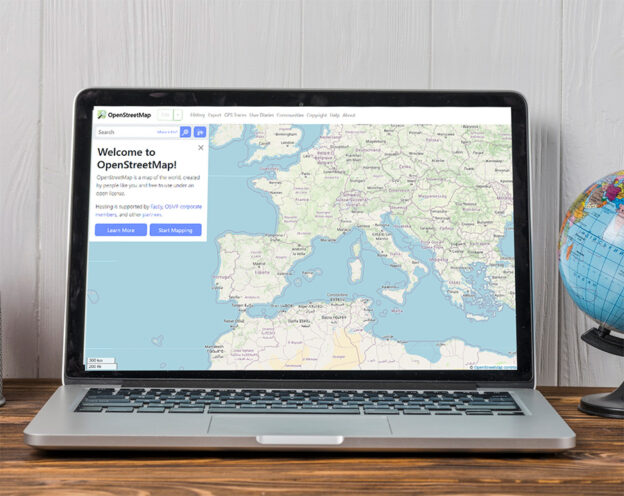
OpenStreetMap: The Free, Editable Map of the World

OpenStreetMap, often abbreviated as OSM, is a collaborative project that aims to create a free, editable map of the entire world. It was founded in 2004 by Steve Coast in the United Kingdom, inspired by the success of open-source software such as Wikipedia. Unlike proprietary map services, OpenStreetMap’s data is freely available for anyone to use, modify, and distribute.

Part of Luxembourg in Open Streetmap

How It Works

OpenStreetMap relies on contributions from a large community of volunteers known as “mappers.” These contributors use GPS devices, aerial imagery, and local knowledge to add and update map data. Everything from roads, rivers, and railways to shops, hiking trails, and bicycle paths can be mapped. The data is stored in a central database and continuously improved by users worldwide.

Open Data for Everyone

All OSM data is released under the Open Database License (ODbL). This means it can be freely used by individuals, companies, and governments as long as credit is given to OpenStreetMap and its contributors. Many organizations use OSM data as the foundation for mapping applications, humanitarian efforts, and research projects.

Humanitarian Mapping

One of the most significant uses of OpenStreetMap is in disaster response and humanitarian aid. The Humanitarian OpenStreetMap Team (HOT) coordinates volunteers who rapidly map affected areas after natural disasters such as earthquakes, floods, or hurricanes. These maps help relief agencies navigate and plan their operations in regions where up-to-date commercial maps are often unavailable.

Global Collaboration

OpenStreetMap is a truly global community project. Thousands of people around the world contribute daily, adding new information, correcting errors, and enhancing details. Local mapping events, known as “mapathons,” bring together volunteers who work together to improve specific areas. The result is a constantly evolving, high-quality map that reflects the real world more accurately than many commercial alternatives.

OpenStreetMap Europe

Iran Considers Moving Its Capital from Tehran

Since 2010, Iran’s government has considered relocating the national capital away from Tehran. The reasons include severe air pollution, traffic congestion, overpopulation, and the high risk of earthquakes. Tehran has grown rapidly and now has over 13 million residents in its metropolitan area.

Skyline of Tehran with Milad tower at sunset.

The issue returned to the spotlight in 2025, when President Ebrahim Raisi stated in October that a relocation is necessary due to worsening water shortages and Tehran’s overstretched infrastructure. His statement marked increased political pressure to act after years of stalled debate.

The proposal was formally endorsed by the Iranian parliament in 2010, and a council was established to explore alternatives. The plan could involve transferring governmental functions to another city, while Tehran would remain the country’s economic center. Similar arrangements exist in other countries, such as South Africa and the Netherlands.

Cities such as Isfahan, Qom, and Semnan have been mentioned as potential new capitals. So far, however, no concrete move has taken place, largely due to economic and administrative obstacles. Still, the crisis of 2025 may prove to be a turning point in the long-running discussion.

Iran diskuterar att flytta huvudstaden frĂĄn Teheran

Sedan 2010 har Irans regering övervägt att flytta landets huvudstad bort från Teheran. Anledningarna är flera: Teheran är tätbefolkat, drabbat av luftföroreningar, trafikproblem och risker för jordbävningar. Staden har vuxit snabbt och har nu över 13 miljoner invånare i storstadsområdet.

Skyline of Tehran with Milad tower at sunset.

Frågan har återigen hamnat i fokus under 2025, då president Ebrahim Raisi i oktober uttalade att en flytt är nödvändig på grund av den förvärrade vattenkrisen och Teherans överbelastade infrastruktur. Uttalandet markerade ett ökat politiskt tryck för att agera efter många års stillastående diskussioner.

Förslaget stöddes formellt av parlamentet redan 2010, och ett råd skapades för att undersöka möjliga alternativ. Flytten skulle kunna innebära att regeringsfunktioner flyttas till en annan stad, medan Teheran fortsätter vara landets ekonomiska centrum. En liknande uppdelning finns redan i flera länder, till exempel Sydafrika och Nederländerna.

Några av de städer som diskuterats som alternativ är Isfahan, Qom och Semnan. Hittills har dock ingen konkret flytt skett, och projektet har bromsats av ekonomiska och administrativa hinder. Men 2025 års kris kan bli en vändpunkt i den långdragna processen.

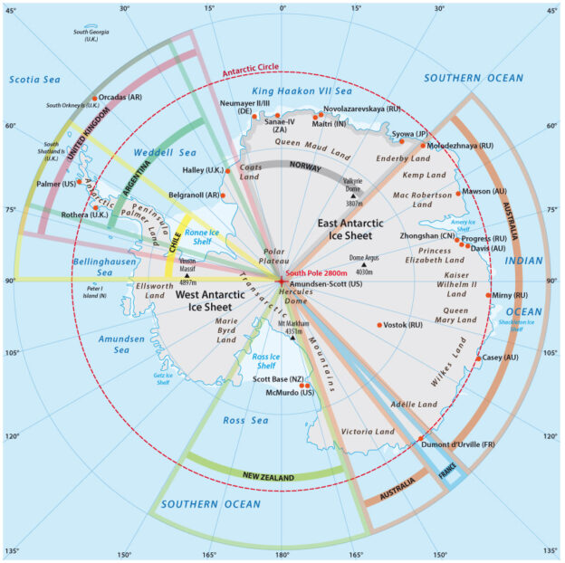
Antarctica political map

The Political Geography of Antarctica

Antarctica is unique among the world’s continents. It has no permanent population, no sovereign government, and no universally recognized national borders. Instead, it is governed by a series of international agreements that regulate how countries may use the land and resources there.

The cornerstone of this system is the Antarctic Treaty, signed in 1959 and in force since 1961. The treaty freezes all territorial claims, bans military activity, and promotes scientific cooperation. More than 50 countries are parties to the treaty, including all major powers.

Before the treaty, several nations declared overlapping claims—among them the United Kingdom, Chile, Argentina, Australia, New Zealand, France, and Norway. The United States and Russia reserved the right to make claims but never did. Because of the treaty, these claims exist on paper only and cannot be enforced or expanded.

Antarctica political map
Map of research stations and territorial claims in Antarctica

In practice, this means no country can treat its claimed sector as sovereign territory, for example, by enforcing laws, building military bases, or excluding others.

Today, the continent is divided into research zones rather than political units. Over 70 permanent research stations operate under national programs, but all follow the treaty’s principles. Antarctica thus represents an unusual form of international governance—territory shared for peaceful purposes, dedicated entirely to science.

Massachusetts Is Choosing a New Flag

In 2025, Massachusetts is in the midst of updating its state flag and related symbols. The process began after the Legislature voted to establish a special commission to study the issue and recommend alternatives. The effort aims to create a design that represents all residents, acknowledges the Commonwealth’s history, and is easy to recognize and reproduce. 

The finalist flag proposals

Supporters of change argue that state symbols should reflect shared civic values and avoid imagery that can be read as celebrating colonial violence. They point to modern design standards and the importance of inclusive symbolism in a diverse society. Criticism of the current flag, which dates back to the early 1900s, intensified in the 2010s and led directly to the commission’s creation.

The current flag of Massachusetts

The redesign process in 2025 includes public outreach, submission of design proposals, expert review, and rounds of refinement. Input is being gathered from residents, historians, designers, and representatives of Indigenous communities to ensure the final result is accurate, respectful, and functional.

Common design goals include simplicity, meaningful symbolism, and strong color contrast. Successful flags are identifiable at a distance, printable at small sizes, and workable without text or seals. Symbols that reference the state’s natural features, civic ideals, or historical milestones are often favored.

The redesign process in 2025 has produced three finalist flag proposals. The first design, known as the “Blue Hill Banner,” features a golden star above rolling blue hills and waves, symbolizing Massachusetts’ landscape and maritime heritage. The second design highlights the mayflower, the state flower, with a white blossom on a dark blue background and a central golden star, linking natural beauty with civic identity. The third design presents a deep red field with six white turkey feathers arranged in a circle, referencing Indigenous symbolism and Massachusetts’ status as the sixth state admitted to the Union. 

Once a preferred design emerges, it will move to elected officials for formal approval, most likely in 2026. Implementation would then include updating flag displays at public buildings, revising digital assets, and phasing in changes to official publications and merchandise over the following years.

Residents can participate by following public meetings, reviewing proposed designs, and submitting feedback. Broad participation helps ensure the flag represents the Commonwealth as it is today and stands the test of time.


Transnistria: The Frozen Conflict on Europe’s Edge

Where is it? Transnistria is a narrow strip of land along the Dniester River, right next to Ukraine. Officially it belongs to Moldova, but the region runs its own government from the city of Tiraspol.

What is it? Transnistria calls itself a republic. It has its own flag, army, police, currency, and number plates. Still, almost no countries recognize it as independent. On most maps, it’s marked as part of Moldova.

The flag of Transnistria

How did it start?

When the Soviet Union collapsed in 1991, Moldova became independent. People in Transnistria, many of them Russian-speaking, feared being absorbed into a more Romanian-oriented Moldova. In 1990 they declared their own “Pridnestrovian Moldavian Republic.” Fighting broke out in 1992, but a ceasefire stopped the war that summer. Since then, the situation has been stuck—neither peace nor full war. That’s why it’s called a “frozen conflict.”

Russia’s role

Russian soldiers have stayed in Transnistria since the ceasefire. Some are there as “peacekeepers,” while others guard a massive old weapons depot at Cobasna. This presence ties the region closely to Moscow and creates tension with Moldova and its Western partners.

Recent tensions

From time to time, Transnistrian leaders ask for stronger ties with Russia, saying Moldova is pressuring them. Moldova, on the other hand, insists the region should be reintegrated peacefully. With Russia’s war in Ukraine nearby, these tensions sometimes rise, raising fears the conflict could spread.

Moldova and the EU

Moldova is working to join the European Union. Any deal about Transnistria’s future will have to fit into this larger process. For now, though, the question remains unresolved.

Life in Transnistria

People living there use the local Transnistrian ruble, but often need Moldovan, Russian, or Ukrainian passports to travel. Streets are filled with Russian, Romanian (Moldovan), and Ukrainian languages. Daily life looks fairly normal, but the political status of the region is unusual.

Why it matters

Transnistria may be small, but it sits at a very sensitive spot—between Moldova, Ukraine, and the European Union. What happens there affects the stability of Eastern Europe. As long as the conflict remains frozen, the risk of it unfreezing will always be in the background.

Countries Whose Capital Shares the Same Name

In some countries, the capital city has exactly the same name as the country itself. In other cases, the capital has a closely related name, differing only slightly in form. These naming patterns often reflect the historical origins of the state and the strong role the capital has played in shaping national identity.

Singapore and San Marino

Exact matches

The following countries have capitals that share the exact same name as the country (sometimes with the addition of “City” in English for clarity):

  • Andorra — Andorra la Vella (commonly shortened to Andorra)
  • Djibouti — Djibouti
  • Guatemala — Guatemala City
  • Kuwait — Kuwait City
  • Luxembourg — Luxembourg
  • Mexico — Mexico City
  • Monaco — Monaco
  • Panama — Panama City
  • San Marino — San Marino
  • Singapore — Singapore
  • Vatican City — Vatican City

Near matches

In these cases, the capital’s name is very similar to the country’s, with only a small variation in spelling or form:

  • Algiers — Algeria
  • BrasĂ­lia — Brazil
  • Santo Domingo — Dominican Republic
  • San Salvador — El Salvador
  • Bissau — Guinea-Bissau
  • SĂŁo TomĂ© — SĂŁo TomĂ© and PrĂ­ncipe
  • Taipei — “Chinese Taipei” (Taiwan, Republic of China)
  • Tunis — Tunisia

Together, these examples show how closely the identity of some nations is tied to their capital cities, either through identical names or through slight variations that reflect shared origins.

Learn more about world capitals in our map quiz Capitals of 60 Largest Countries by Population